Let’s get your map creating skills up a notch, shall we?
Some travelers had difficulty changing the color and shape of their pins so we wanted to show you how to do that.
When you are editing a project, you can see a pin for each location in the Map module. Click a pin and the customization options will be revealed.
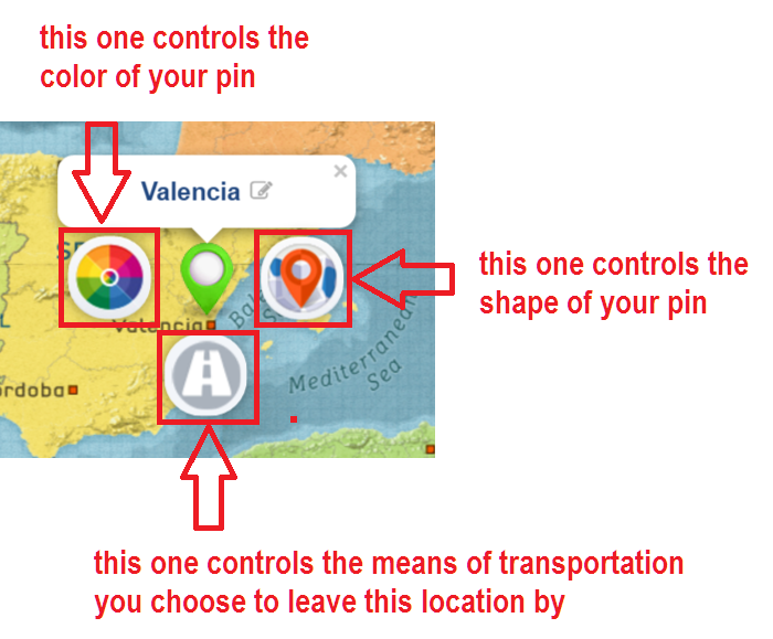
The left one lets you customize the color of your pin, and the right one controls its shape. The one below the pin controls the mode of transportation you leave the location in.
On click, the available customization options for each pin control will be revealed:
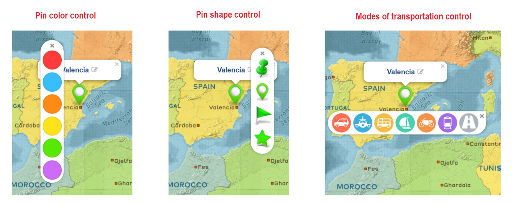
Come on, try it now. Log in to your account, go to edit a project and click a pin to change its color and shape, or to add a mode of transportation to a location.
A Pro tip
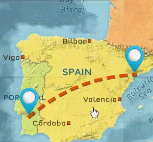
We’ll let you in on a little-known feature – you can also customize the color of the path between locations.
While in the Map module, hover your mouse over the path. It will slightly change its color being highlighted. Click it and additional color controls will be revealed. Choose the colors to your liking and you can have a dotted line path in one or two colors 😉
Come on, try it now. Log in to your account, go to edit a project and click a path to customize its color.
If you don’t have an account yet, join now and start creating animated travel maps within minutes after completing your registration.
Hi – Thanks for your system. It is great 🙂 It would be better to have some more means of transportation: Bicycle and walking. Please ad this. Thanks
Thanks for your feedback Sem, glad you like the platform. We develop new features based on user demand – more means of transportation are already on our to-do list. As soon as we have enough demand for bicycle and walking, we’ll add those. In the meantime, you can use the motorcycle instead of a bike – wouldn’t it work for you?
Thanks for using PictraMap!
~Diana
I would also like to see walking mode added as many people do walking holidays and hikes
Hello Frances, thanks for the feedback! As mentioned in previous comments, a walking icon is already on our to-do list – if/when we have enough demand for it, we’ll plan development accordingly. In the meantime, you may just remove the mode of transport and show only the travel path. Would that work for you?
Hope this helps and thanks for PictraMapping your trips with us 🙂
~Diana
Hi Diana thanks you very much for your tips. This app is great and easy to use.
It would be good if we have the option to modify the colors of the transportation means, for example, I would like to change the current red color of the car by another one.
Thanks and greetings from Chile.
Thanks for taking the time to send us your feedback Alejandro, much appreciated! I think you’re the first to ask for such a feature so I’m adding it to the list of requested features. If/when we have enough demand for it, we’ll plan development.
Thanks for using PictraMap!
~Diana
Are there any other options for mode of transport? The sailboat looks like a pirate ship. Do you have one that looks like an actual sailboat?
Hello Rejean, thanks for taking the time to send us your feedback and request through a comment on our blog. What you see is what’s available at the moment.
As pointed out in previous comments, we develop new features based on user demand – more means of transportation (incl. a different look of the ship) are already on our to-do list. As soon as we have enough demand, we’ll plan development accordingly. In the meantime, you can just turn off the means of transportation if a ship doesn’t work for you.
Hope this helps and thanks for using PictraMap!
~Diana
Hi!
Looking for some great samples of PictraMap and see that path between stop points are curved.
How do you achieve that? When I make my map all lines go straight. Is it possible when using a car to draw simulation of road path?
Thanks.
Marko
Hi Marko, you can bend the travel path between two locations – just hover with your mouse over the travel path and when it gets highlighted, left click – this will “catch” the travel path. Now drag it – this way you will bend it so it’s a curve and not a straight light. Release your mouse and the path will take the new shape.
IF you want to create more complex ravel paths, then you can do that by adding waypoints – check out this blog post for info on what way points are and how you can create them. https://www.pictramap.com/how-to-show-photos-between-locations/ (the posts goes one step further and explains how to show photos on your way between two locations but ultimately, it starts with adding a waypoint 🙂 )
You can simulate the actual road paths if you add enough waypoints, I guess, but you cannot do it automatically.
Hope this helps and thanks for using PictraMap!
~Diana
Hi
Thanks for a great easy way to make animate maps. Can you add a person as an transportation?
Regards
Odd
Thanks for the feedback and for the feature request. By person as a means of transport, do you mean some type of a walking icon? (To show you walked vs used an actual transport mode?) If so, you’d be pleased to know it’s already on our to-do list – if/when we have enough demand for it, we’ll plan development accordingly. In the meantime, you may just remove the mode of transport and show the path only. Hope this helps and thanks for PictraMapping your trips with us 🙂
Stay safe!
~Diana
Dear Daina
At the moment the line between two points in the route is direct line< is impossible to change it to follow the road in between ?
regards
Hello Hadi, thanks for taking the time to post a comment.
Regarding the ability to mimic realistic routes you would see on Google Maps – that is not possible with PictraMap and not in our plans for the moment. However, you may create more complex travel paths and shapes (instead of the simple curved ones) by adding waypoints. While it will not automatically mimic a real road, you can certainly have a more complex route instead of the straight or bent line between two locations. Check out this post – it’s about something else (showing photos on the way between locations) but it also discusses how to add a waypoint.
Please try it and let me know if this would work for you.
Thanks,
Diana
HI! I love what you have created! I was wondering if there is a way to add my own sailboat drawing to the animation, vs the pirate ship one that is there? Thanks so much for what you have created!
Hello Olivia! Thanks for your kind words and for taking the time to send us your feedback through a comment on our blog.
There is no option to add your own means of transportation to the animation, I am sorry. We do have a list of requested transportation modes though (like a sailing boat, bike, other types of cars, planes and boats, etc.) so if/when we have enough demand for any of those, we’ll plan development accordingly.
Thanks for PictraMapping your trips with us. Happy sailing and stay safe 🙂
~Diana
Hi there, I just can not find the way to delete a pin from my map – is there a shortcut?
thanks
Charles
Hello Charles, to delete a pin, you need to delete the location from the left handside sidebar – where all your locations are… once you delete the location, the pin will disappear from the map. Please try it and let me know how it goes, or if you have other questions.
Thanks for PictraMapping your trips with us.
Happy travels and stay safe!
~Diana